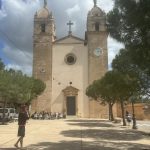



Heute am 12. April dem letzten Tag unseres Radurlaubs, an dem wir noch Radfahren konnten, haben wir eine 100 km Tour gemacht, die Route: Marratxi, Santa Maria, Alaro, Sencelles, Algaida, Llucmajor
Gruß
Edi
Die zurückgelegte Strecke als Open Street Map Karte mit Höhenprofil und Zusatzinfos
Malle Tour Marratxi, Santa Maria, Alaro, Sencelles, Algaida, Llucmajor – 12.04.2024
Map of the route “12. April 2024 Mallorca 7. Tag – Marratxi, Santa Maria, Alaro, Sencelles, Algaida, Llucmajor”: 100.165 m, 814 m of climbing and 793 m of descent, elevation between 39 m and 301 m, time 04:59:21. It starts at 39.51518, 2.74898 and ends at 39.52370, 2.73775 (latitude, longitude).
Gesamtstrecke: 100246 m
Maximale Höhe: 301 m
Minimale Höhe: 39 m
Gesamtanstieg: 814 m
Gesamtabstieg: 793 m
Gesamtzeit: 04:59:26
Download file: 2024-04-12-edi-teppert-com-MallorcaRadurlaub2024.gpx
Maximale Höhe: 301 m
Minimale Höhe: 39 m
Gesamtanstieg: 814 m
Gesamtabstieg: 793 m
Gesamtzeit: 04:59:26